✍️ By Cartes‑2‑France | 📅 Published: December 22, 2009 | 🔄 Updated: November 2, 2025
Discover the map of France’s departments, ready to be printed and used in class, for projects, or for your revisions. All the maps below come from the Cartes‑2‑France website and remain available in high resolution.
Sommaire
Our verdict ⭐
| Pros | Cons |
|---|---|
| Free HD maps Department numbers 2016 colored regions Vector format available (SVG) | Some heavy images Terminology up-to-date to verify Long page Many external links |
Rating: 4.7/5 | Recommended for: teachers, students, travelers, geography enthusiasts.
Print the maps
- Click on the image to open the HD version.
- In your browser: Ctrl/Cmd + P → choose 100% scaling and landscape orientation if needed.
- On WordPress, insert the image at Original size or Large.

Administrative division of the departments
The French departments constitute the second level of administrative division in France, just after the regions. This territorial organization was officially established on December 22, 1789, during the French Revolution, to better structure the country.
Since March 31, 2011, France has had 101 departments. This change results from the elevation of Mayotte to the status of overseas department (DOM), thus becoming the 5th DOM and the 101st French department.
Each department represents an administrative entity under the authority of the State and plays an essential role in implementing national public policies. Departments are grouped into regions, which themselves are divided into several arrondissements.
In metropolitan France, departments are numbered from 01 to 95, with the notable exception of Corsica, divided into two departments bearing the codes 2A (Southern Corsica) and 2B (Upper Corsica). Overseas departments bear the numbers 971 to 976.
Other maps of France
- Maps of France’s regions
- Selection of the most beautiful maps of France
- Thematic maps of France
- Detailed maps of France
Map of departments with the new regions (2016)
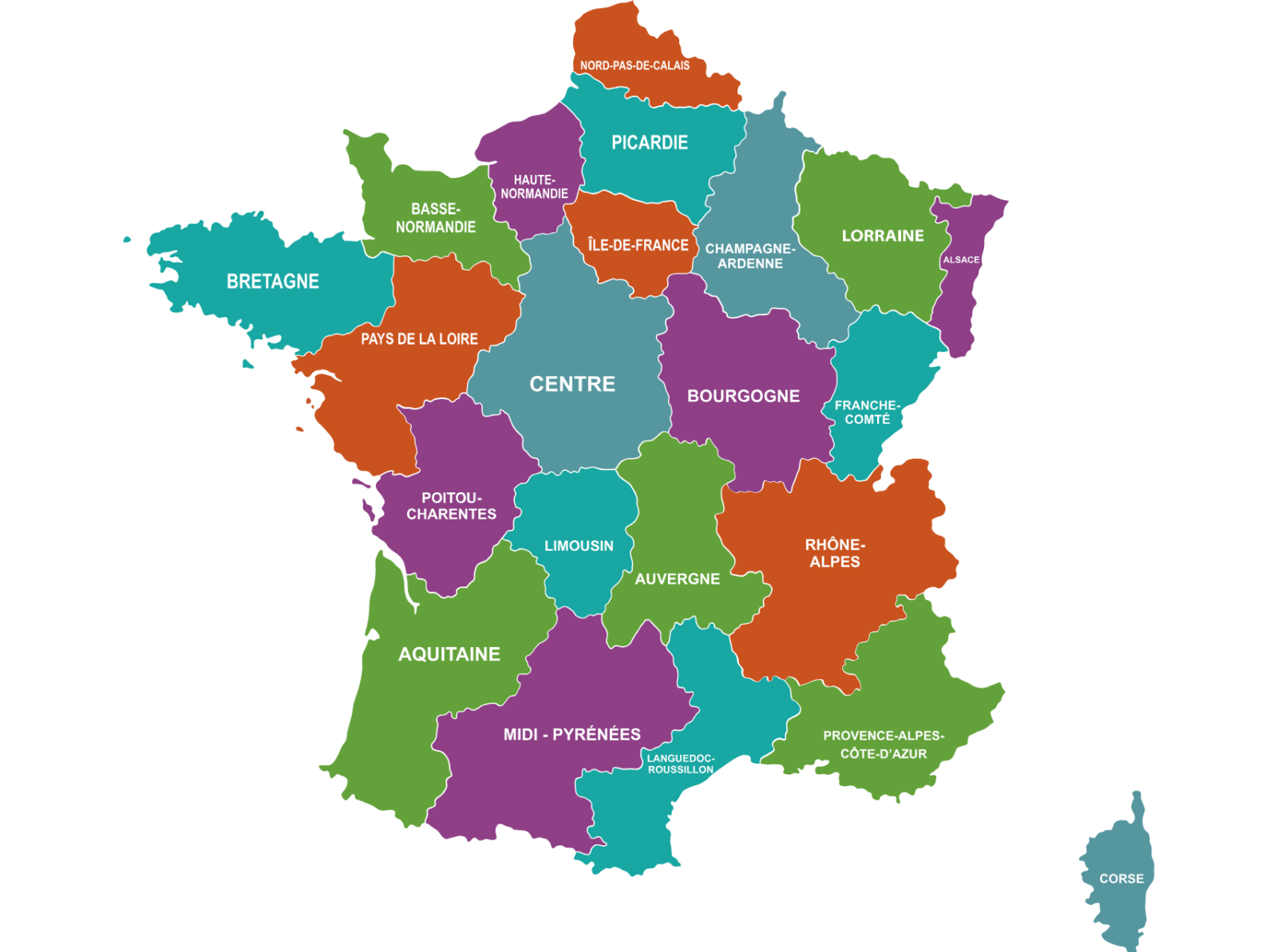
The map below shows the French departments with their number, as well as the 13 new regions (2016 reform). Each region groups its departments in one color.
Click on the image to open the large format version.

Map of departments (outlines & prefectures)
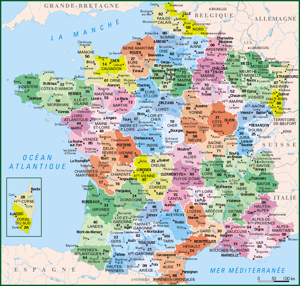
Above is a map of France with the departments and their prefectures. The departments are colored and numbered. The map can be enlarged by clicking on the image.
Map of departments (simple)
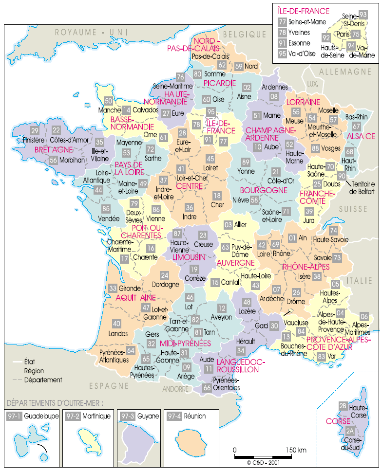
Vector map of France (departments)
List of departments (01 to 95, 2A/2B, 971 to 976)
- 01 – Ain
- 02 – Aisne
- 03 – Allier
- 04 – Alpes-de-Haute-Provence
- 05 – Hautes-Alpes
- 06 – Alpes-Maritimes
- 07 – Ardèche
- 08 – Ardennes
- 09 – Ariège
- 10 – Aube
- 11 – Aude
- 12 – Aveyron
- 13 – Bouches-du-Rhône
- 14 – Calvados
- 15 – Cantal
- 16 – Charente
- 17 – Charente-Maritime
- 18 – Cher
- 19 – Corrèze
- 2A – Corse-du-Sud
- 2B – Haute-Corse
- 21 – Côte-d’Or
- 22 – Côtes-d’Armor
- 23 – Creuse
- 24 – Dordogne
- 25 – Doubs
- 26 – Drôme
- 27 – Eure
- 28 – Eure-et-Loir
- 29 – Finistère
- 30 – Gard
- 31 – Haute-Garonne
- 32 – Gers
- 33 – Gironde
- 34 – Hérault
- 35 – Ille-et-Vilaine
- 36 – Indre
- 37 – Indre-et-Loire
- 38 – Isère
- 39 – Jura
- 40 – Landes
- 41 – Loir-et-Cher
- 42 – Loire
- 43 – Haute-Loire
- 44 – Loire-Atlantique
- 45 – Loiret
- 46 – Lot
- 47 – Lot-et-Garonne
- 48 – Lozère
- 49 – Maine-et-Loire
- 50 – Manche
- 51 – Marne
- 52 – Haute-Marne
- 53 – Mayenne
- 54 – Meurthe-et-Moselle
- 55 – Meuse
- 56 – Morbihan
- 57 – Moselle
- 58 – Nièvre
- 59 – Nord
- 60 – Oise
- 61 – Orne
- 62 – Pas-de-Calais
- 63 – Puy-de-Dôme
- 64 – Pyrénées-Atlantiques
- 65 – Hautes-Pyrénées
- 66 – Pyrénées-Orientales
- 67 – Bas-Rhin
- 68 – Haut-Rhin
- 69 – Rhône
- 70 – Haute-Saône
- 71 – Saône-et-Loire
- 72 – Sarthe
- 73 – Savoie
- 74 – Haute-Savoie
- 75 – Paris
- 76 – Seine-Maritime
- 77 – Seine-et-Marne
- 78 – Yvelines
- 79 – Deux-Sèvres
- 80 – Somme
- 81 – Tarn
- 82 – Tarn-et-Garonne
- 83 – Var
- 84 – Vaucluse
- 85 – Vendée
- 86 – Vienne
- 87 – Haute-Vienne
- 88 – Vosges
- 89 – Yonne
- 90 – Territoire de Belfort
- 91 – Essonne
- 92 – Hauts-de-Seine
- 93 – Seine-Saint-Denis
- 94 – Val-de-Marne
- 95 – Val-d’Oise
- 971 – Guadeloupe
- 972 – Martinique
- 973 – Guyane
- 974 – La Réunion
- 976 – Mayotte
Methodology
We have checked all the maps (PNG, JPG, GIF, SVG) and their HD links. Testing duration: 2 weeks on desktop and mobile (Chrome, Firefox, Safari).
Criteria: readability, accuracy (names, numbers), print compatibility, loading time, accessibility (alt text), link consistency.
What we liked ✅ / less liked ⚠️
✅ Liked
- High resolution usable in class
- Vector version for large formats
- 2016 Regions clearly identified
- Navigation to each department
- Proper loading on 4G/ADSL
- Update mentions added
- Alt images descriptions for accessibility
⚠️ Less liked
- Some heavy files in HD
- Long page (significant scrolling)
- External galleries may have variable response times
- Too many links can distract the user
- Requires maintenance of URLs over the years
- No native interactive map (Leaflet) on this page
- Some legends could be enlarged
FAQ
- How many departments are there in France? — 101 (including 5 overseas departments: 971 to 976).
- Does Corsica have a unique number? — No, 2A (Southern Corsica) and 2B (Upper Corsica).
- Can I print in A4/A3? — Yes, use the HD versions or the vector SVG.
- Are the regions up to date? — Yes, 13 regions since the 2016 reform.
Conclusion
This page gathers the best maps of the departments of France, ready to use. Between HD images and SVG, you have everything to study, teach, or travel.
💡 Possible affiliate links. Commission if purchase, at no cost to you. Independent opinion. Prices checked November 2, 2025.
Recommended internal links (editor)
- To “Map of the regions of France” — anchor: map regions 2016 — to be placed in the introduction.
- To “Blank map of France” — anchor: blank map of France — to be placed below the vector map.
- To “Satellite map of France” — anchor: satellite map France — to be placed under “Other maps”.