Map of the regions of France (13 regions) – HD to print

✍️ By Cartes-2-France | 📅 Published: | 🔄 Updated:

Map of France of the 13 metropolitan regions (2016 reform) in high definition 2160p
HD map of the 13 regions metropolitan (2016 reform) – click for the 4K version.

Our verdict ⭐

ProsCons
Clear HD 4K quality; 13 regions well contrasted; direct download; simple printing A4/A3. No prefectures on the HD map; minimal legend; image size somewhat large on mobile.

Rating: 8.5/10 | Recommended for: middle/high school, teachers, travelers, presentations.

How to download & print the map

  1. Click on “View in HD” (or on the image) to open the original.
  2. Save the image (Right click → Save image as…).
  3. Print in A4 (home) or A3/A2 (printer).
  4. Settings: “Fit to page” (full size) or 100 % (actual scale).

Other maps of France

Map of the regions of France
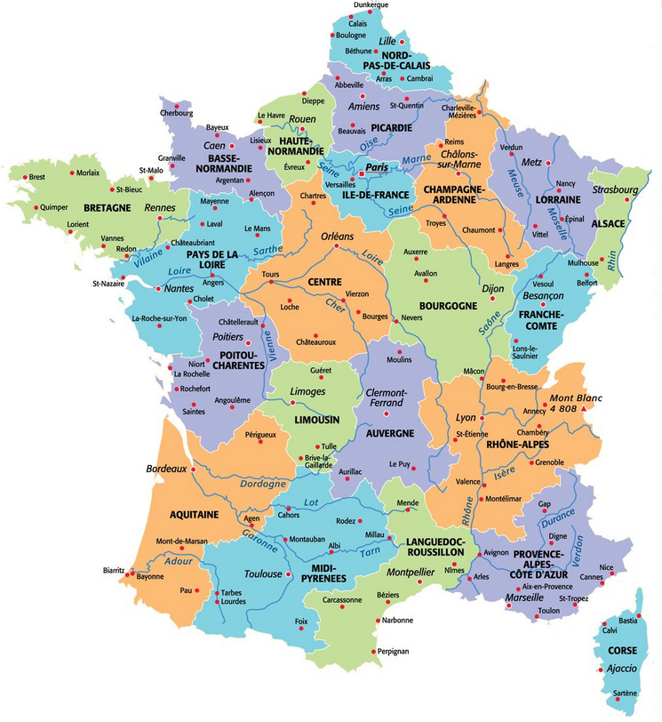
Administrative map of the regions of France — 13 metropolitan regions + 5 overseas

French regions

France had 22 metropolitan regions (before 2016) and 5 Overseas regions, making a total of 27 regions. Since the reform of January 1, 2016, there are 18 regions: 13 in metropolitan France and 5 DROM.

List of 13 regions (metropolitan) & capitals

  • Auvergne-Rhône-AlpesLyon
  • Bourgogne-Franche-Comté — Dijon
  • Brittany — Rennes
  • Centre-Val de Loire — Orléans
  • Corsica — Ajaccio
  • Grand EstStrasbourg
  • Hauts-de-France — Lille
  • Île-de-France — Paris
  • Normandy — Rouen
  • Nouvelle-Aquitaine — Bordeaux
  • Occitanie — Toulouse
  • Pays de la Loire — Nantes
  • Provence-Alpes-Côte d’Azur — Marseille

Overseas regions (DROM)

  • Guadeloupe — Basse-Terre
  • Martinique — Fort-de-France
  • French Guiana — Cayenne
  • Réunion — Saint-Denis
  • Mayotte — Dzaoudzi

Tip: use the Itineraries tool to connect two regions or departments.

Former regions (before 2016)

For reference, here is the list of the 22 historical metropolitan regions:

  • Alsace
  • Aquitaine
  • Auvergne
  • Lower Normandy
  • Burgundy
  • Brittany
  • Centre
  • Champagne-Ardenne
  • Corsica
  • Franche-Comté
  • Upper Normandy
  • Île-de-France
  • Languedoc-Roussillon
  • Limousin
  • Lorraine
  • Midi-Pyrénées
  • Nord-Pas-de-Calais
  • Pays de la Loire
  • Picardy
  • Poitou-Charentes
  • Provence-Alpes-Côte d’Azur
  • Rhône-Alpes

Map of France’s regions after the 2016 reform

Map of France's regions after the 2016 reform (metropolitan + Overseas) in high definition

Territorial reform 2016: reminder in 5 points

  • Change from 22 to 13 metropolitan regions.
  • Objectives: clarity, efficiency, economies of scale.
  • Notable mergers (e.g. Alsace-Lorraine-Champagne-Ardenne → Grand Est).
  • Retention of the 5 DROM (Guadeloupe, Martinique, Guyana, Réunion, Mayotte).
  • Update of administrative maps and prefectures.

What are the regions for?

The regions correspond to the largest administrative division in France; they are divided into departments (in some DROMs, region and department coincide). Today, there are 18 regions: 13 metropolitan and 5 overseas.

The regions are governed by an elected regional council, chaired by a regional president. They have no legislative power but have extensive competencies (high schools, transport, economic development…).

For more information on each region, use the internal links and the itinerary tool.

What we liked ✅ / liked less ⚠️

✅ Liked

  • Contrast and clarity of the 13 regions
  • HD format suitable for A4/A3 printing
  • Direct access to download
  • Multiple complementary maps (departments, relief, satellite…)
  • Rich internal linking
  • Clean print function
  • Reminder of the 2016 reform

⚠️ Liked less

  • Old list of 22 regions can be confusing if poorly contextualized
  • Few legends/annotations on the HD map
  • Image weight somewhat high on mobile
  • No prefectures on the HD map

Methodology

Maps designed from official administrative data and a harmonized cartographic base.

Criteria: accuracy of boundaries, clarity, contrast, compatibility with printing (A4/A3) and screen (HD/4K).

FAQ – Map of regions

Can I reuse the map?

Yes, by citing Cartes-2-France with a clickable link (see box “Data reuse”).

What formats do you recommend?

A4 at home; A3/A2 at a printer for better clarity.

Is the map up to date?

Yes, updated on 11/02/2025 (2016 reform integrated).

Where to find the departments and cities?

See the map of departments and the map of cities.

Conclusion

This map of the regions offers a clear view of France post-2016 reform, ready to print in HD and to use in class, at the office or on travel.

To go further: relief, satellite, telephone area codes, rivers.

Reuse of data

You may reuse the maps and information on this page, only if you cite Cartes-2-France with a clickable link.
Without this link, reuse is not authorized.

Code to copy:

Source: <a href="https://www.cartes-2-france.com" title="Cartes-2-France — reuse authorized">Maps of France</a> > <a href="https://www.cartes-2-france.com/carte-regions-france.php" title="source">source</a>

Preview: Source: Maps of France > source

💡 Affiliate links may be present. Possible commission in case of purchase, at no cost to you. Independent opinion. Information verified on 11/02/2025.

{ “@context”:”https://schema.org”, “@type”:”WebPage”, “name”:”Map of the regions of France (13 regions) – HD to print”, “inLanguage”:”fr”, “datePublished”:”2021-03-12″, “dateModified”:”2025-11-02″, “url”:”https://www.cartes-2-france.com/carte-regions-france.php”, “breadcrumb”:{ “@type”:”BreadcrumbList”, “itemListElement”:[ {“@type”:”ListItem”,”position”:1,”name”:”Home”,”item”:”https://www.cartes-2-france.com/”}, {“@type”:”ListItem”,”position”:2,”name”:”Cartography”,”item”:”https://www.cartes-2-france.com/cartographie/”}, {“@type”:”ListItem”,”position”:3,”name”:”Map of the regions of France”} ] } } { “@context”:”https://schema.org”, “@type”:”FAQPage”, “mainEntity”:[ {“@type”:”Question”,”name”:”Can I reuse the map?”,”acceptedAnswer”:{“@type”:”Answer”,”text”:”Yes, provided you cite Cartes-2-France with a clickable link (see the “Reuse of data” box).”}}, {“@type”:”Question”,”name”:”How to download and print in good quality?”,”acceptedAnswer”:{“@type”:”Answer”,”text”:”Open the HD map, save the image on your computer then print in A4 (home) or A3/A2 at a printer. Enable “Fit to page” or 100% according to your need.”}}, {“@type”:”Question”,”name”:”Is the map up to date?”,”acceptedAnswer”:{“@type”:”Answer”,”text”:”Yes, updated on 11/02/2025. It includes the 13 metropolitan regions resulting from the 2016 territorial reform and the 5 overseas regions.”}}, {“@type”:”Question”,”name”:”Where to find departments and cities?”,”acceptedAnswer”:{“@type”:”Answer”,”text”:”Consult the map of departments and the map of cities via the internal links.”}} ] } .regions-13,.regions-om,.reg-li{columns:2;column-gap:28px} (function(){ // utilities function sameOrigin(u){ try{ const a=new URL(u,location.href); return a.origin===location.origin; }catch(e){ return false; } } function filenameFrom(url){ try{ const u=new URL(url,location.href); return (u.pathname.split(‘/’).pop()||’carte.jpg’).split(‘?’)[0]; }catch(e){ return ‘carte.jpg’; } } async function download(url, name){ if(sameOrigin(url)){ const a=document.createElement(‘a’); a.href=url; a.download=name||filenameFrom(url); document.body.appendChild(a); a.click(); a.remove(); return; } try{ const r=await fetch(url,{mode:’cors’}); const b=await r.blob(); const o=URL.createObjectURL(b); const a=document.createElement(‘a’); a.href=o; a.download=name||filenameFrom(url); document.body.appendChild(a); a.click(); a.remove(); setTimeout(()=>URL.revokeObjectURL(o),1500); }catch(e){ window.open(url,’_blank’); } } function printMap(opts){ const {src, title, caption, credit, ratio=1} = opts; const landscape = ratio>1.1; const w=window.open(”,’_blank’,’noopener,noreferrer’); const css=`@page{size:A4 ${landscape?’landscape’:’portrait’};margin:12mm;} `; const html=` ${(title||’Map to print’).replace(/</g,'<')} ${css}

${(title||’Map of the regions of France’).replace(/</g,'<')}

${new Date().toLocaleDateString(‘fr-FR’)}
${ (caption||credit) ? `
${caption?caption.replace(/</g,'<'):''}${credit?`
${credit.replace(/</g,'<')}`:”}
` : ” }
Source: Cartes-2-France
A4 ${landscape?’landscape’:’portrait’}
window.onload=function(){setTimeout(function(){window.print();},120);}`; w.document.open(); w.document.write(html); w.document.close(); } function enhance(fig){ if(fig.dataset.c2fDone) return; const img = fig.querySelector(‘img’) || fig; if(!img) return; const link = fig.querySelector(‘a’); const full = link ? link.getAttribute(‘href’) : (img.dataset.full || img.currentSrc || img.src); const name = img.getAttribute(‘data-filename’) || filenameFrom(full); const title = img.getAttribute(‘data-title’) || document.querySelector(‘h1,h2’)?.textContent || ‘Map’; const caption = img.getAttribute(‘data-caption’) || img.getAttribute(‘alt’) || ”; const credit = img.getAttribute(‘data-credit’) || ”; const w = parseInt(img.getAttribute(‘width’)||’0′,10); const h = parseInt(img.getAttribute(‘height’)||’0′,10); const ratio = (w>0 && h>0) ? (w/h) : (img.naturalWidth && img.naturalHeight ? img.naturalWidth/img.naturalHeight : 1); // anti-distortion img.style.width=’100%’; img.style.height=’auto’; img.style.objectFit=’contain’; // actions const actions = document.createElement(‘div’); actions.className=’c2f-actions’; const bDl = document.createElement(‘button’); bDl.type=’button’; bDl.className=’c2f-btn c2f-btn–download’; bDl.textContent=’Download’; bDl.addEventListener(‘click’, e=>{ e.preventDefault(); download(full, name); }); const bPr = document.createElement(‘button’); bPr.type=’button’; bPr.className=’c2f-btn c2f-btn–print’; bPr.textContent=’Print’; bPr.addEventListener(‘click’, e=>{ e.preventDefault(); printMap({src:full, title:title, caption:caption, credit:credit, ratio:ratio}); }); actions.appendChild(bDl); actions.appendChild(bPr); fig.appendChild(actions); fig.dataset.c2fDone=’1′; } function scan(){ document.querySelectorAll(‘figure.wp-block-image, .entry-content figure, .entry-content img:not(figure img)’).forEach(el=>{ const fig = el.matches(‘figure’) ? el : el.closest(‘figure’) || el.parentElement || el; enhance(fig); }); } if(document.readyState===’loading’){ document.addEventListener(‘DOMContentLoaded’, scan); } else { scan(); } new MutationObserver(scan).observe(document.body,{childList:true,subtree:true}); })();