
In brief
🗺️ The shrink-swell clay map indicates an overall soil exposure, not the actual condition of a house. It is used to rank the risk before purchase.
🏠 In areas of medium or high hazard, the map should be cross-checked with visible cracks, foundations, nearby trees, drainage, and technical documents.
📌 Since the 2018 Élan law, the map governs prescriptions for constructions in medium and high zones. The 2026 version becomes applicable from July 1, 2026 for certain deeds and contracts.
🔎 The right reflex: read the map, visit differently, request available documents, then decide between purchase, negotiation, geotechnical study, or abandoning the project.
Why does the shrink-swell clay map really matter before a purchase?
The shrink-swell clay map does not say if a property is good or bad to buy. It helps identify a risk of soil movement that can weaken a house. Before buying, it should be cross-checked with the building’s condition, the land’s environment, and, if necessary, a geotechnical study.
Shrink-swell of clays is one of those topics many buyers discover too late, often after a stair-step crack, a sticking door, or a terrace slightly detaching from the wall. Yet, the data exists, it is public, and it deserves to be consulted as naturally as the cadastre, the local urban plan (PLU), or the urban planning certificate.
The national update of the RGA zoning, enacted by an order of January 9, 2026, aims precisely to integrate the recent high claims rate. According to the BRGM, about 240,000 claims related to shrink-swell of clay soils were declared between 2018 and 2022, representing a very large share of claims recorded since 1989. So this is not an administrative detail hidden in a sales file. It is an indicator that can change the economic and technical reading of a property.
In short, well-located, sunny, buildable, and properly serviced land can present an invisible constraint: soil sensitive to moisture variations. And this constraint does not necessarily forbid buying. It rather requires buying differently, with more method, more documents, and sometimes a budget for securing.
A color on a map neither buys nor sells a house: it indicates the level of caution to adopt before committing.
The real risk for the buyer
The risk is not “having clay” per se. Many clay soils host houses stable for decades. The real issue is the combination of sensitive soil, inadequate foundations, repeated droughts, nearby vegetation, poor water management, and building history. When these factors add up, differential soil movements can create stresses on the structure.
In practice, buyers rarely see the problem in geological terms. They see it as drought house cracks, masonry repairs, open joints, cracked tiles, or recent works with unclear explanations. That is why the map should trigger a closer inspection, not automatic panic.
It is observed in the field that real estate visits often go too quickly over side facades, window corners, and annexes. Yet these are precisely the areas that sometimes reveal the first signs of differential movements, especially after several dry summers.
How does the shrink-swell of clays work?
The shrink-swell of clays corresponds to the volume variation of certain clayey soils. In wet periods, they swell; in dry periods, they shrink. These movements can be uneven under a house and cause cracks, especially if the foundations are shallow or poorly adapted.
The mechanism is quite simple to visualize. Clays work a bit like a mineral sponge: they absorb water, then lose it. When they dry, the soil volume decreases; when they re-moisten, it increases. The problem is that this movement is not always uniform under the entire construction. One part of the ground may shrink more than another, especially near a tree, a very exposed facade, or a poorly drained area.
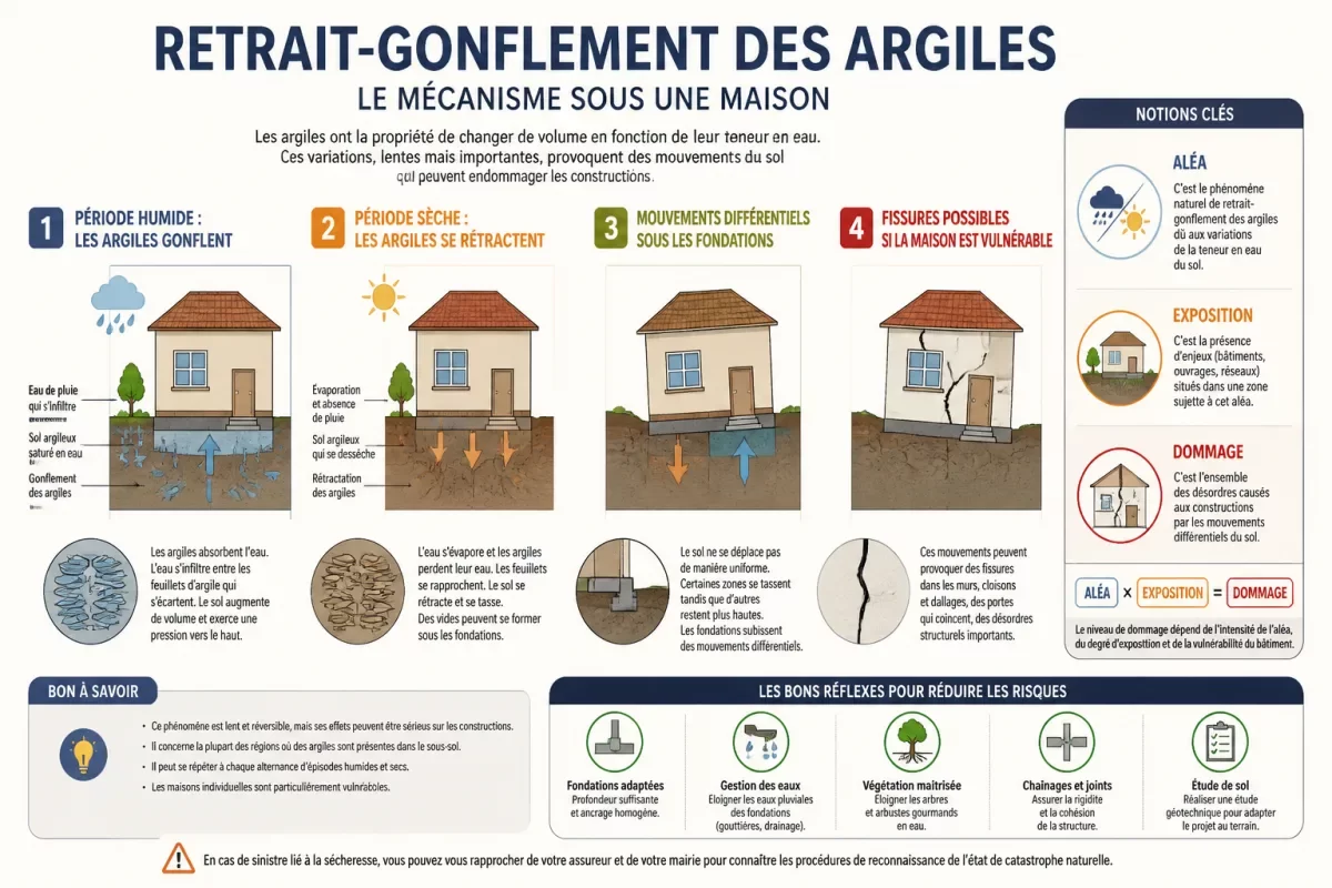
That is why three often confused concepts are distinguished: hazard, exposure, and damage. Hazard describes the soil’s susceptibility to the phenomenon. Exposure locates the property in an affected area. Damage depends on the construction, its age, its foundations, its maintenance, and its immediate environment. In other words, the map speaks of a context, not a structural diagnosis.
- Clay hazard: probability that the soil is sensitive to moisture variations.
- Property exposure: position of the land or house in a mapped area.
- Actual damage: observable or technically demonstrated disorder on the construction.
- Vulnerability: building’s capacity to resist soil movements.
According to the BRGM website on the evolution of the national exposure map, the update takes into account the effects of recent significant claims. This is where the analysis becomes interesting: climate change does not necessarily create clay, but it intensifies drought episodes that reveal the weaknesses of the soil-building pair.
The most sensitive properties
Individual houses are particularly concerned, especially when they rest on shallow or old foundations. Extensions, attached garages, verandas, and terraces can also move differently from the main building. It is not necessarily spectacular at first, but these repeated shifts sometimes eventually cause cracks or opening defects.
A real estate agent based in a peri-urban municipality observes that buyers often focus on the roof and the energy performance diagnosis (DPE), but much less on the foundations and the soil. Joking aside, it is understandable: you see a boiler, you do not see the water behavior of a plot. Hence the interest in starting from the map, then returning to the site with a more technical eye.
How to read the clay shrink-swell map step by step?
To read the clay shrink-swell map, start by precisely locating the property on the official map, then identify the indicated exposure level. Next, check if the information concerns a large sector or a parcel. Finally, compare this data with the visible condition of the house, available documents, and the context of the land.
The safest reflex is to consult the official map on Géorisques, then zoom in sufficiently to locate the land. The RGA exposure map covers metropolitan France excluding Paris and can also be downloaded by departments in SIG Shapefile format, with Lambert 93 projection according to Géorisques. For a private individual, the online interface is sufficient in most cases; for a professional, the SIG data allow for a more detailed cross-check.
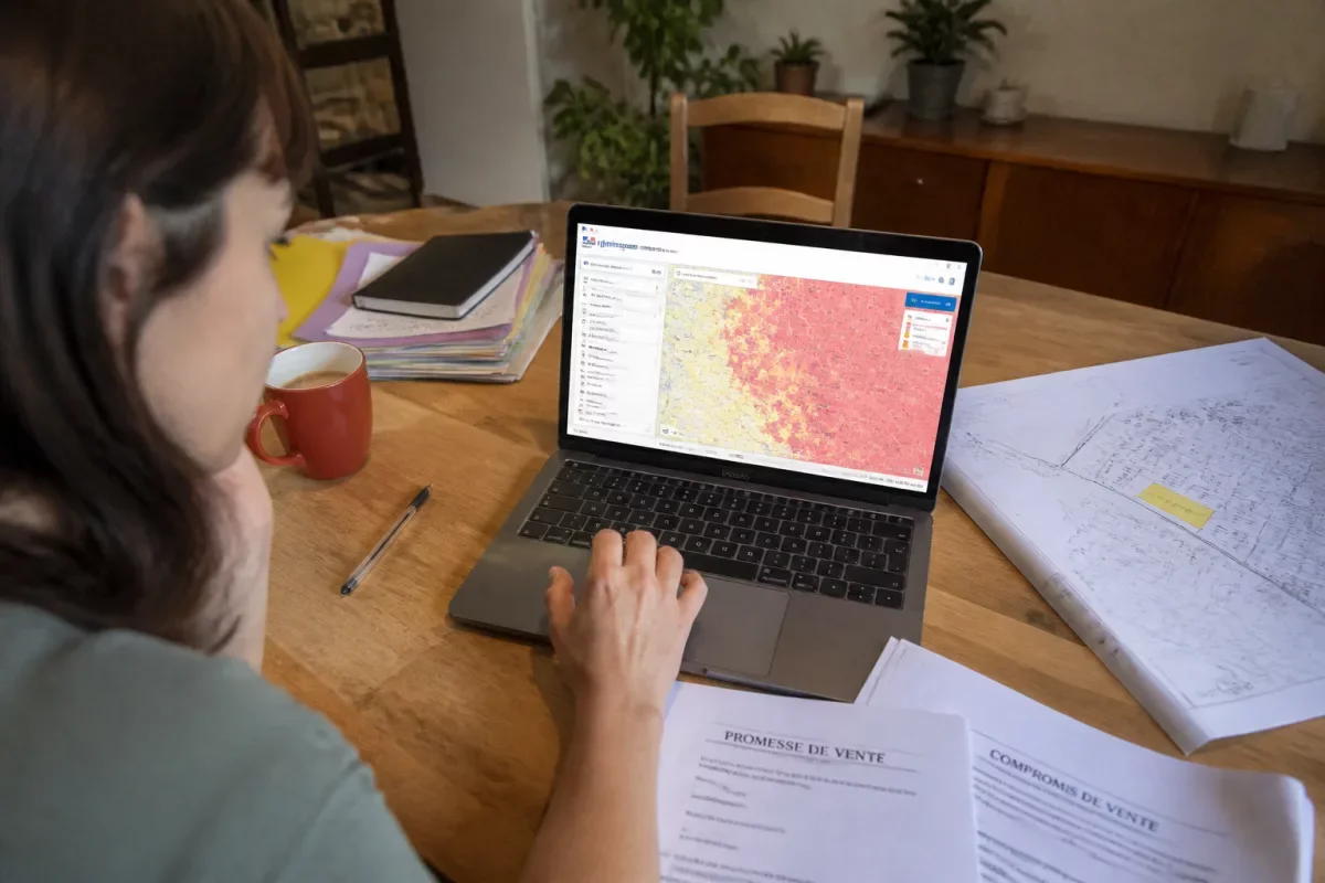
The classic trap is to read the map at the municipal scale and draw too quick a conclusion. The same municipality can include very different areas. Conversely, two neighboring houses may react differently if one is old, the other recent, if the foundations are not comparable, or if rainwater is better managed on one of the plots.
- Search for the address on the Clay Shrink-Swell Risk Map or via the municipality.
- Zoom in to the property’s area to avoid too general a reading.
- Note the exposure level: low, medium, or high according to the displayed zoning.
- Compare with on-site observations: cracks, vegetation, slopes, water runoff.
- Request technical documents from the seller, builder, or notary.
To secure a land purchase, this reading must also be combined with urban planning regulations. A plot may be buildable but exposed to a hazard that requires a specific technical approach. On this point, the verification of buildability remains complementary: PLU, cadastre, urban planning certificate, and clay map do not answer the same question.
What does each hazard level mean for a buyer?
A low hazard calls for normal vigilance, a medium hazard requires enhanced checks, and a high hazard often justifies a technical approach before commitment. The displayed level does not automatically predict cracks, but it changes the level of caution, the questions to ask, and the value of a geotechnical study.
The map’s color should be read as a vigilance slider. It does not replace the eye of a professional, a soil study, or the building’s history. However, it helps avoid a common mistake: treating all plots as if they behaved the same way. This is especially important when you want to buy clay land to build a single-family home.
| Exposure Level | Interpretation for the Buyer | Recommended Action |
|---|---|---|
| Low | The risk exists but appears limited at the mapped scale. | Check for cracks, water runoff, and seller’s documents. |
| Medium | The soil may require serious technical vigilance. | Request the property’s history and consider a soil study depending on the project. |
| High | The risk must be factored into the price, project, and possible works. | Strengthen inspections, consult a geotechnician, and avoid signing blindly. |
Since the Élan law of 2018, the exposure map serves as a framework for implementing adapted prescriptions for constructions in medium and high exposure zones. The new RGA map will be annexed to sales promises or authentic sales deeds of buildable undeveloped land, as well as to individual house construction contracts concluded from July 1, 2026, according to official information relayed by Géorisques and BRGM.
The higher the hazard, the less the purchase should rely on an impression from a visit; it must rely on evidence, documents, and a technical analysis.
What does the clay shrink-swell risk map not say?
The map does not indicate whether a house is cracked, if its foundations are suitable, or if works will be necessary. It also does not alone predict the appearance of defects. It indicates a general geological exposure, to be supplemented by a careful visit, seller’s documents, and, if needed, an expert assessment.
This is the most important point to avoid misunderstandings. A high hazard zone is not automatically a no-buy zone. And a low hazard zone does not guarantee a flawless house. The map is an information layer, not an X-ray of the property. It must be linked to concrete clues: construction era, foundation quality, visible repairs, vegetation, slope, stormwater management, presence of old or recent cracks.
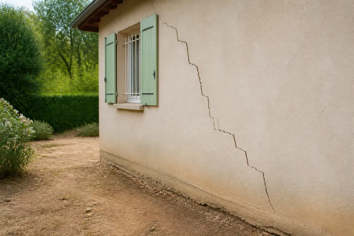
On site, clues are not all of equal value. A microcrack in plaster may be trivial. A through crack, stair-step shaped, that widens or reappears after repair, deserves much more attention. The same logic applies to doors that rub: a poorly adjusted carpentry does not have the same meaning as a set of consistent disorders on several facades.
A family who arrived in 2022 in a rural municipality recounts having renegotiated their offer after encountering three elements: medium hazard zone, cracks repaired on a facade, and no available soil study. The seller had not hidden the issue, but no one had really connected it to the land before the second visit.
Clues to check during the visit
Without becoming a building expert, a buyer can already observe several signals. The idea is not to make a definitive diagnosis, but to spot what justifies a question, a request for documents, or a technical opinion.
- Stair-step cracks on masonry walls or at the corners of openings.
- Recent plaster repairs, localized touch-ups, or suspicious color differences.
- Trees very close to the facades, especially if their roots can influence soil moisture.
- Defective gutters, downspouts, or inspection chambers that concentrate water near the foundations.
- Terrace, garage, or extension showing a misalignment with the main house.
- Exterior soil that shrinks during dry periods or retains water after heavy rains.
Good to know: the site Géorisques on the 2026 exposure map provides access to public reference data. For an individual, this at least allows verifying that the information used in the purchase discussion is not based on an old screenshot or an oral approximation.
What to do according to the clay risk level before signing?
In low hazard, verify without dramatizing. In medium hazard, document and question more. In high hazard, integrate the risk into the decision, price, and technical conditions. In all cases, the map should guide a progressive approach, not trigger an automatic decision.
The right approach is to turn the map into an action plan. If the exposure is low and the house shows no worrying signs, a documentary check may suffice. If the exposure is medium or high, especially with visible cracks or a construction project, a soil study becomes much more relevant. It allows moving from a general risk to a more local understanding of the land.
For a building plot, the issue is even more direct: it is not only about knowing if the land is “risky,” but how to design the foundations and arrangements. More suitable foundations, water management, distancing of plantings, uniform bearing: these are design decisions, not mere details.
| Encountered situation | Level of caution | Possible decision |
|---|---|---|
| House without visible cracks in low hazard | Moderate | Check documents and rainwater maintenance. |
| Old house in medium hazard with plaster repairs | High | Request the history of works and consider a technical opinion. |
| Buildable land in high hazard | Very high | Plan a geotechnical study before finalizing the project. |
| Reported evolving cracks after drought | Very high | Do not sign without documents, expert assessment, or appropriate clause. |
There is also a public aid component for owners already affected. Since October 2025, aid for the prevention of clay shrink-swell has been tested in 11 pilot departments: Allier, Alpes-de-Haute-Provence, Dordogne, Gers, Indre, Lot-et-Garonne, Meurthe-et-Moselle, Nord, Puy-de-Dôme, Tarn, and Tarn-et-Garonne. According to Service-Public.fr, an order dated April 23, 2026, effective May 1, 2026, expanded the scope of this experiment and relaxed certain conditions.
This aid should not be confused with a peaceful purchase guarantee. It concerns regulated situations and specific criteria. For example, during the work phase, the maximum crack width condition is raised to 5 mm instead of 1 mm under the relaxation mentioned by Service-Public.fr on drought crack-related aid. This type of information can help an owner, but the buyer must especially anticipate before becoming an owner.
Checklist before signing: what questions to ask?
Before signing, ask if the property has already shown cracks, if structural repairs have been carried out, if a soil study exists, and if the land has experienced changes in drainage or vegetation. These answers help connect the official map to the real history of the property.
The checklist is your best ally to avoid the “we’ll see later” approach. Once the promise is signed, negotiation margins shrink. Beforehand, you can still request documents, condition your offer, adjust the price, or take time for a specialized opinion. This is not being suspicious; it is buying methodically.
- Has the property ever been subject to a drought-related damage claim?
- Have cracks been filled, monitored, or assessed?
- Is there a geotechnical study, even an old one, related to the construction or an extension?
- Have underpinning, drainage, or consolidation works been carried out?
- Have trees near the facades been planted, cut down, or heavily pruned recently?
- Is rainwater kept away from foundations or discharged too close to the building?
In the presence of a notary, these questions can be framed within the context of information attached to the sale. For undeveloped buildable land, the new zoning applicable from July 1, 2026, reinforces the importance of verifying the consistency between official information, urban planning documents, and the construction project. In other words, you don’t just look at a color: you check what it implies legally, technically, and financially.
What documents to request to link the map to the actual property?
Useful documents include the official Géorisques map, cadastral references, available diagnostics, work invoices, expert reports, old soil studies, and urban planning information. Their value lies in moving from a theoretical risk to a concrete understanding of the land or house.
A serious seller does not necessarily have all the answers, especially for an old house. But they can provide clues: invoices for crack repairs, insurance files, expert reports, studies done during an extension, foundation plans, builder documents. Taken individually, each document may seem technical; together, they outline the property’s history.
The geotechnician intervenes when the issue goes beyond simple observation. This is particularly useful when the purchase involves a building plot, a cracked house, a planned extension, or a high risk. The study is not meant to “scare,” but to adapt the project: foundation depth, uniformity of the base, water management, planting precautions, treatment of sensitive areas.
The right decision is not always to give up: sometimes it is to buy cheaper, build differently, or secure the project before signing.
That is why the clay shrink-swell map should be considered as an analysis filter. It does not replace expertise, but it prevents asking the right questions too late. Cherry on the cake: it is free, public, and clear enough to guide an initial decision, provided it is not overinterpreted.
Key Takeaways
- 🗺️ The map indicates soil exposure, not the exact technical condition of a house.
- 🏚️ Cracks must be cross-checked with the risk level, the building’s age, and the foundations.
- 🔎 In medium or high risk areas, a soil study can become a real decision-making tool.
- 📄 The seller’s documents count as much as the color shown on the map.
- 💬 Clay risk can justify negotiation, not necessarily automatic abandonment.
FAQ
What is clay shrink-swell?
Clay shrink-swell is a soil movement related to moisture variations. Clays swell when they absorb water and shrink when they dry. Under a house, these movements can create stresses and cause cracks if the construction is vulnerable.
Is it risky to buy a house on clay soil?
It is not automatically risky, but it requires more checks. A well-designed, well-maintained house without damage can still be a reasonable purchase. However, in medium or high risk areas with visible cracks, it is better to request technical documents or expert advice before signing.
How can I tell if my land is in a clay zone?
The easiest way is to consult the Géorisques clay map with the property’s address or municipality. You then need to zoom in at the right level and compare the information with cadastral references. For a construction project, a soil study remains the most reliable way to assess the actual situation of the plot.
Is a soil study mandatory before buying?
It is not mandatory in all purchase cases, but it can be strongly recommended depending on the exposure level, type of project, and condition of the property. For a building plot in a medium or high risk area, it mainly allows adapting the foundations and avoiding building “blindly.”
Do cracks in a house always come from clay?
No. Cracks can come from settlement, construction defects, structural modifications, water problems, or material aging. The clay shrink-swell map helps formulate a hypothesis, but only a technical analysis can clearly link the cracks to the soil.