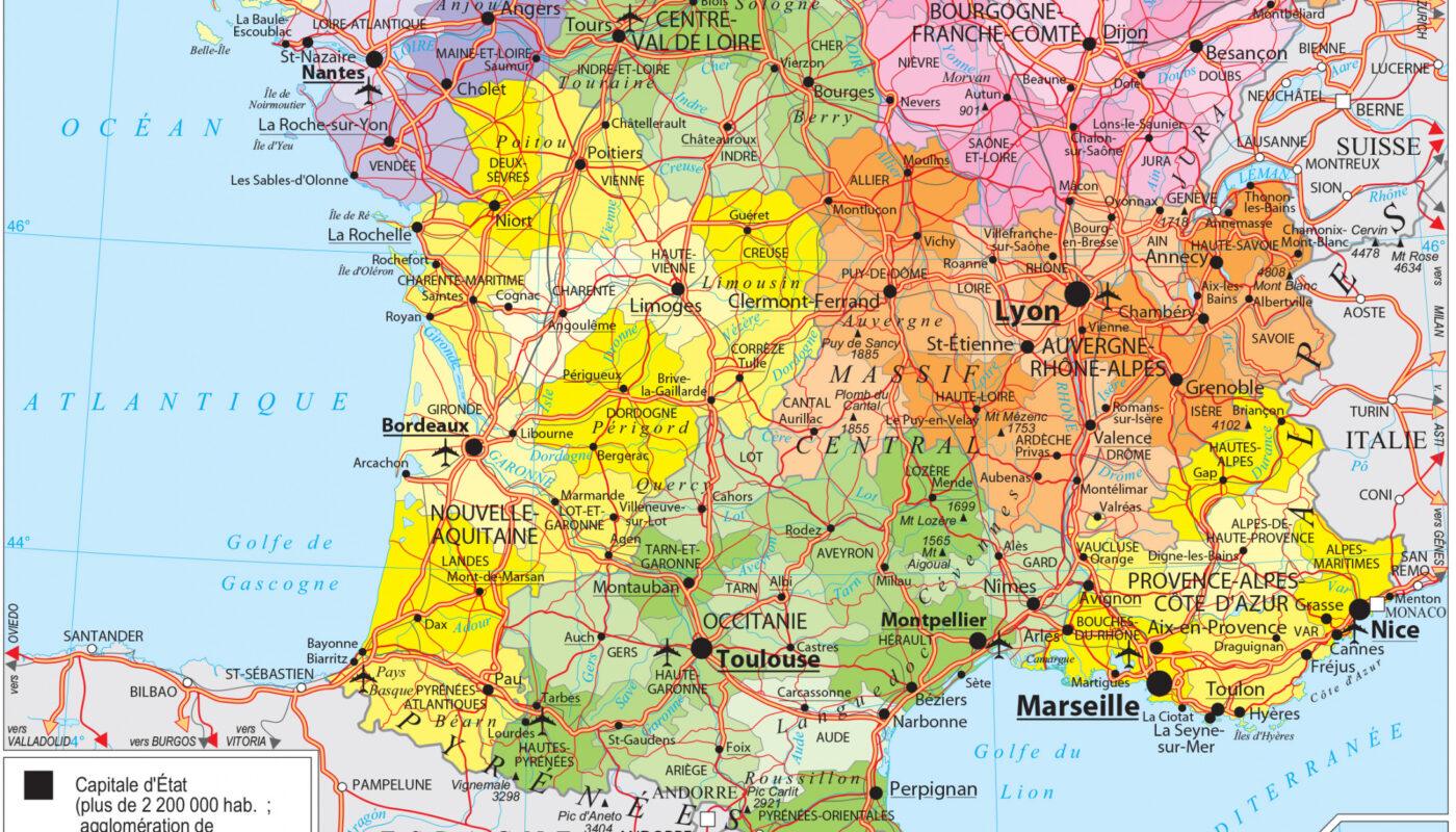
Check out our high-definition map of France to discover the complete geography of the French territory.
You will find the 13 regions, the 96 departments, the main cities, the major roads, as well as a dedicated inset for Overseas France.
A practical tool for students, travelers, or map enthusiasts.

Sommaire
History of the map of France: The 2016 territorial reform
Before 2016, metropolitan France had 22 regions. The law of January 16, 2015 deeply reformed the administrative division, reducing the number of regions.
Effective date: January 1, 2016. Final decree: September 29, 2016. This historic overhaul led to 7 major regional mergers.
Main mergers:
- Aquitaine + Limousin + Poitou-Charentes → Nouvelle-Aquitaine
- Auvergne + Rhône-Alpes → Auvergne-Rhône-Alpes
- Champagne-Ardenne + Lorraine + Alsace → Grand Est
- Languedoc-Roussillon + Midi-Pyrénées → Occitanie
- Bourgogne + Franche-Comté → Bourgogne-Franche-Comté
- Nord-Pas-de-Calais + Picardie → Hauts-de-France
- Basse-Normandie + Haute-Normandie → Normandie
Result: from 27 regions (metropolitan + overseas) to 18 current regions. 13 metropolitan regions and 5 overseas regions.
The 13 regions of metropolitan France
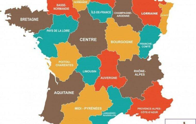
Metropolitan France is now divided into 13 regions. This detailed map highlights the regional borders with a distinct color code for each.
This allows easy visualization of the location and extent of large regions such as Nouvelle-Aquitaine, Île-de-France, Provence-Alpes-Côte d’Azur, or Occitanie.
Table of the 13 metropolitan regions
| Region | Capital | Number of departments | Approximate population |
|---|---|---|---|
| Île-de-France | Paris (75) | 8 depts | 12.0 million |
| Auvergne-Rhône-Alpes | Lyon | 12 depts | 8.1 million |
| Provence-Alpes-Côte d’Azur | Marseille | 6 depts | 5.1 million |
| Nouvelle-Aquitaine | Bordeaux | 12 depts | 6.0 million |
| Occitanie | Toulouse | 13 depts | 6.3 million |
| Bourgogne-Franche-Comté | Dijon | 8 depts | 2.8 million |
| Hauts-de-France | Lille | 5 depts | 6.0 million |
| Pays de la Loire | Nantes | 5 depts | 3.9 million |
| Bretagne | Rennes | 4 depts | 3.4 million |
| Centre-Val de Loire | Orléans | 6 depts | 2.5 million |
| Grand Est | Strasbourg | 10 depts | 5.8 million |
| Normandie | Rouen | 5 depts | 3.3 million |
| Corse | Ajaccio | 2 depts | 0.3 million |
Each region has a prefecture which is the administrative seat. The regional capitals are generally the largest cities in their region.
Departments and their numbering
Each region is subdivided into departments. There are 96 in metropolitan France, numbered from 01 to 95 (plus Corsica 2A/2B).
These department codes are ubiquitous in French administration: license plates, postal codes, phone numbers, administrative forms.
How does department numbering work?
The department numbering system follows a relatively coherent geographical logic.
Main ranges:
- 01-19: Regions in the East and Northeast (Ain, Aisne, Allier…)
- 20-2B: Corsica (special case, see details below)
- 21-95: Logical geographical sequence north-south and east-west
- 971-976: Overseas departments and territories (special codes for overseas)
Why Corsica? The department number 20 existed until 1976. That year, it was split into two: Corse-du-Sud (2A) and Haute-Corse (2B).
Common usage: If you see a license plate ending with “75”, it is a vehicle from Île-de-France (Paris). “69” corresponds to the Rhône Region (Lyon).
Partial list of department codes
Some examples of numbered departments by region:
- Île-de-France: Paris (75), Seine-et-Marne (77), Yvelines (78), Essonne (91), Hauts-de-Seine (92), Seine-Saint-Denis (93), Val-de-Marne (94), Val-d’Oise (95)
- Nouvelle-Aquitaine: Charente (16), Charente-Maritime (17), Corrèze (19), Dordogne (24), Gironde (33), Landes (40), Lot-et-Garonne (47), Pyrénées-Atlantiques (64), Vienne (86), Deux-Sèvres (79), Creuse (23), Haute-Vienne (87)
- Provence-Alpes-Côte d’Azur: Alpes-de-Haute-Provence (04), Hautes-Alpes (05), Alpes-Maritimes (06), Bouches-du-Rhône (13), Var (83), Vaucluse (84)
- Grand Est: Ardennes (08), Aube (10), Marne (51), Haute-Marne (52), Meurthe-et-Moselle (54), Meuse (55), Moselle (57), Bas-Rhin (67), Haut-Rhin (68), Vosges (88)
Major cities and their territorial influence
The map of France identifies the main cities that structure the national territory. These metropolises exert regional or even national influence.
The major French metropolises
- 🟦 Paris: capital of France and a major economic center. Region: Île-de-France. Population: 2.2 million (metro area: 12 million).
- 🟧 Lyon: industrial and cultural hub of the center-east. Region: Auvergne-Rhône-Alpes. Second largest metro area in France. Population: 1.7 million.
- 🟨 Marseille: main Mediterranean port. Region: Provence-Alpes-Côte d’Azur. Third largest city in France. Population: 1.6 million.
- 🟩 Toulouse: major aeronautics hub. Region: Occitanie. Headquarters of Airbus. Population: 1.3 million.
- 🟥 Bordeaux: commercial and wine center. Region: Nouvelle-Aquitaine. Population: 1.2 million.
- 🟥 Lille: economic capital of the north. Region: Hauts-de-France. European metropolis. Population: 1.1 million.
- 🟥 Nantes: important Atlantic port. Region: Pays de la Loire. Population: 0.9 million.
- 🟥 Strasbourg: European administrative center. Region: Grand Est. Seat of the European Parliament. Population: 0.8 million.
- 🟥 Nice: main Mediterranean tourist center. Region: Provence-Alpes-Côte d’Azur. Population: 0.9 million.
These cities radiate well beyond their administrative boundaries through their economic, commercial, and cultural zones of influence.
Overseas France (DOM-TOM)
The detailed map also includes a section dedicated to overseas departments and territories. These territories are essential to the identity and geographical diversity of France.
Difference between metropolitan and overseas
Metropolitan France = 13 continental regions. Overseas France = 5 overseas regions and several sui generis collectivities.
The 5 overseas regions (DOM):
- Guadeloupe (971): Caribbean region. Population: 0.38 million.
- Martinique (972): Caribbean region. Population: 0.37 million.
- French Guiana (973): South America region. Population: 0.29 million.
- Réunion (974): Indian Ocean region. Population: 0.86 million.
- Mayotte (976): Indian Ocean region (since 2011). Population: 0.30 million.
Other French collectivities (not shown on this main map):
- Saint-Pierre-et-Miquelon: North Atlantic archipelago.
- Saint-Barthélemy and Saint-Martin: Caribbean islands.
- French Polynesia: Pacific islands.
- Wallis and Futuna: South Pacific islands.
- Southern and Antarctic Lands: Antarctic territories.
French overseas spans 11 million km² of maritime space, giving France the second largest maritime zone in the world after the United States.
How to use this map of France?
Thanks to its high level of detail, this high-definition map can be used for many purposes:
Educational and professional uses
- 📚 Educational use: School, middle school, high school, university. Perfect for geography and social sciences courses.
- ✈️ Travel planning: Plan a route, identify regions to visit, locate cities of interest.
- 🧭 Territorial visualization: Distribution of populations and economic infrastructures.
- 📍 Administrative context: Understand the French regional and departmental division.
- 🏢 Professional use: Territorial analyses, market studies, commercial prospecting.
- 📖 Research work: Geography, history, political science, spatial planning.
Format and download
This detailed map is available in high-definition PDF, suitable for printing:
- ✅ Format A3 (297 × 420 mm)
- ✅ Format A4 (210 × 297 mm)
- ✅ High resolution (300 dpi)
- ✅ Colors optimized for printing
- ✅ Free to download
Old vs New Regions: Understanding the 2016 reform
To better understand the evolution of the French regional division, here is a summary table of the regional mergers of 2016.
Comparison table of regions
| Region BEFORE 2016 | + | Region AFTER 2016 | New capital |
|---|---|---|---|
| Aquitaine Limousin Poitou-Charentes | → | Nouvelle-Aquitaine | Bordeaux |
| Auvergne Rhône-Alpes | → | Auvergne-Rhône-Alpes | Lyon |
| Champagne-Ardenne Lorraine Alsace | → | Grand Est | Strasbourg |
| Languedoc-Roussillon Midi-Pyrénées | → | Occitanie | Toulouse |
| Bourgogne Franche-Comté | → | Bourgogne-Franche-Comté | Dijon |
| Nord-Pas-de-Calais Picardie | → | Hauts-de-France | Lille |
| Basse-Normandie Haute-Normandie | → | Normandie | Rouen |
| Bretagne | → | Bretagne | Rennes |
| Centre | → | Centre-Val de Loire | Orléans |
| Pays de la Loire | → | Pays de la Loire | Nantes |
| Île-de-France | → | Île-de-France | Paris |
| Corse | → | Corse | Ajaccio |
Summary: The reform created 7 new regions by merger and kept 6 unchanged. The total number went from 22 metropolitan regions to 13 metropolitan regions.
FAQ – Map of France: Frequently Asked Questions
How many regions are there in metropolitan France?
Metropolitan France has 13 regions since the 2016 territorial reform. Before this reform, there were 22.
If you add the 5 overseas regions (Guadeloupe, Martinique, French Guiana, Réunion, Mayotte), the total rises to 18 regions for all of France.
How many departments are there in France?
Metropolitan France has 96 departments, numbered from 01 to 95 (plus Corsica 2A/2B).
With the 5 overseas departments and territories, there are 101 departments in total.
What did the 2016 reform change on the map of France?
The 2016 territorial reform created new regions by merging: Nouvelle-Aquitaine (Aquitaine + Limousin + Poitou-Charentes), Auvergne-Rhône-Alpes (Auvergne + Rhône-Alpes), Grand Est (Alsace + Lorraine + Champagne-Ardenne), etc.
The number of metropolitan regions went from 22 to 13.
Why does Corsica have codes 2A and 2B and not 20?
The department number 20 existed in Corsica until 1976. That year, it was divided into two: Corse-du-Sud (2A) and Haute-Corse (2B).
Instead of renumbering all French departments, the prefix “2” was simply kept with suffixes “A” and “B”.
Can this map of France be printed?
Yes, this high-definition map is specially designed for printing. It is suitable for the following formats:
- ✅ A3 (297 × 420 mm)
- ✅ A4 (210 × 297 mm)
- ✅ High resolution (300 dpi for printing)
What is the difference between metropolitan France and the overseas departments and territories?
Metropolitan France = the 13 continental regions on the European continent.
Overseas France = the 5 overseas regions (Guadeloupe, Martinique, French Guiana, Réunion, Mayotte) + several collectivities (French Polynesia, Wallis and Futuna, etc.).
Geopolitical interest: Overseas gives France the second largest exclusive maritime zone in the world.
Where is the prefecture of my region?
Each region has its prefecture, generally the largest city. Examples:
- Île-de-France: Paris
- Auvergne-Rhône-Alpes: Lyon
- Nouvelle-Aquitaine: Bordeaux
- Occitanie: Toulouse
- Grand Est: Strasbourg
See the full table in the “The 13 regions” section above.
How to read department codes on a license plate?
Each French license plate bears a department number at the bottom right. For example:
- 75 = Paris (Île-de-France)
- 69 = Rhône (Auvergne-Rhône-Alpes)
- 13 = Bouches-du-Rhône (PACA)
- 33 = Gironde (Nouvelle-Aquitaine)
- 67 = Bas-Rhin (Grand Est)
You can instantly identify the geographical origin of a vehicle.
Where to download the detailed map of France?
Go to the “Download” section at the top of this article. The high-definition PDF map is free and ready to print.
Other maps of France to consult
To deepen your knowledge of French geography, discover our other thematic maps:
- Maps of French departments
- Maps of French regions
- Thematic maps of France (climatic, economic, demographic)
- Maps of the old regions before 2016
- Detailed profiles of major cities
- Selection of the most beautiful maps of France
For a complete selection, consult our catalog of maps by themes.
💡 Transparency: Official and up-to-date data. Map and administrative information verified according to the 2025 territorial changes. Official sources: INSEE, Ministry of the Interior, French government. This article may contain internal links. Updated November 2, 2025.