
Are you looking for a printable map of France for your classes, revisions, or professional projects? Whether you are a teacher, student, parent, or professional, having a quality printable map of France is essential. In 2025, many free resources allow you to download maps suited to all needs: blank maps, with regions, departments, or main cities.
TL;DR: Several official sites offer free printable maps of France in high-quality PDF and JPG: IGN, Éduscol, Régions-et-Départements.fr, and CartesFrance.fr. You will find blank maps, with regions (13 metropolitan + 5 overseas), departments (101 total), in color or black and white, all ready to be printed in A4 format.
Sommaire
Types of printable maps of France
There are several categories of printable maps of France, each suited to specific uses:
1. Blank maps or map backgrounds
Blank maps show only the outlines of metropolitan France and possibly the overseas departments. They contain no toponyms (place names). These maps are ideal for:
- School localization exercises
- Geographical knowledge tests
- Educational coloring projects
- Self-learning with self-correction
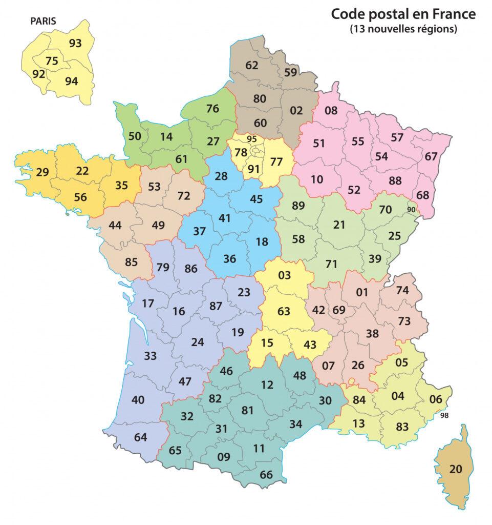
2. Maps with regions
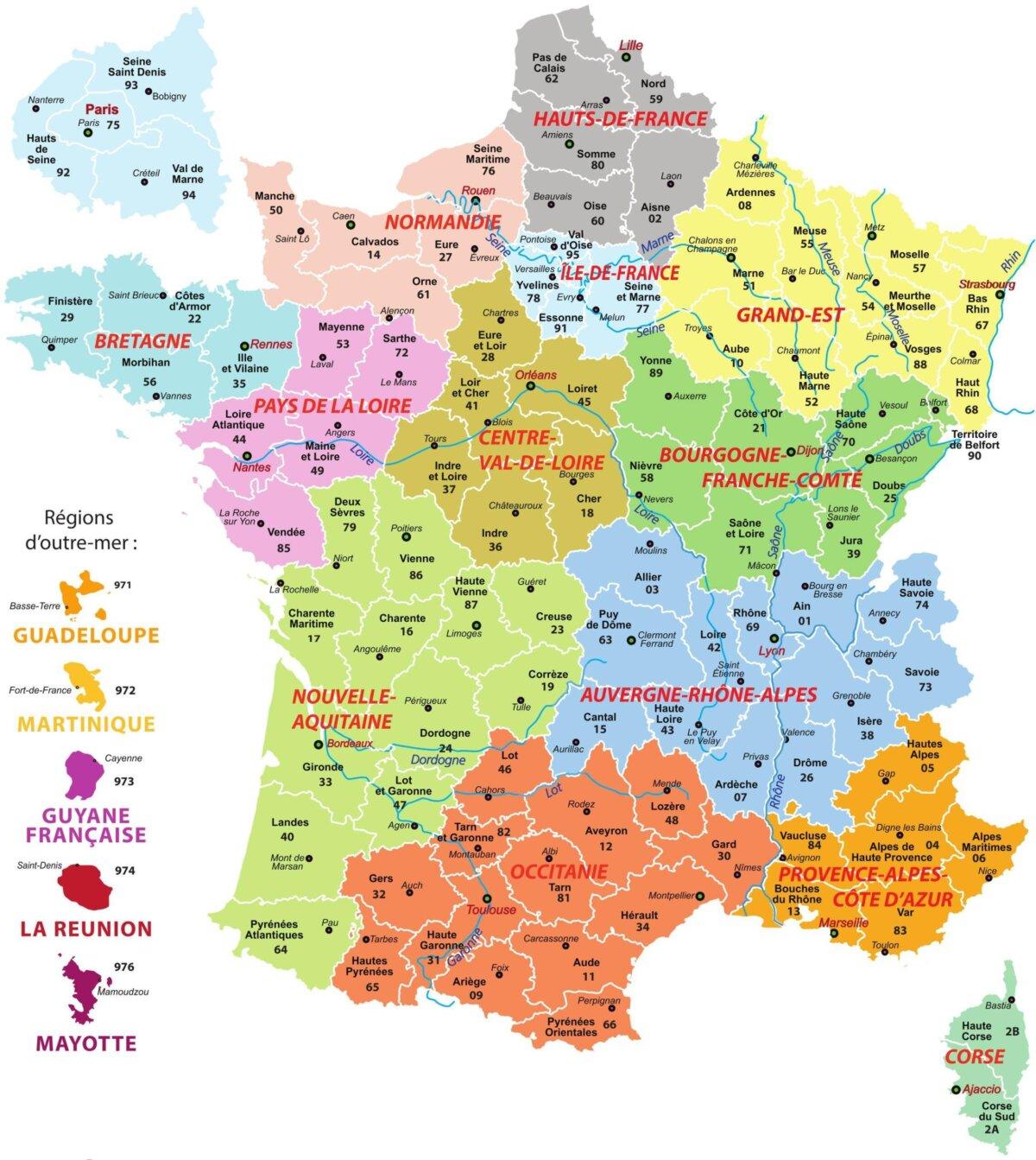
These maps display the 13 metropolitan regions and the 5 overseas regions since the 2016 territorial reform. They exist in several versions:
- With region names
- Without names (blank map with regional outlines)
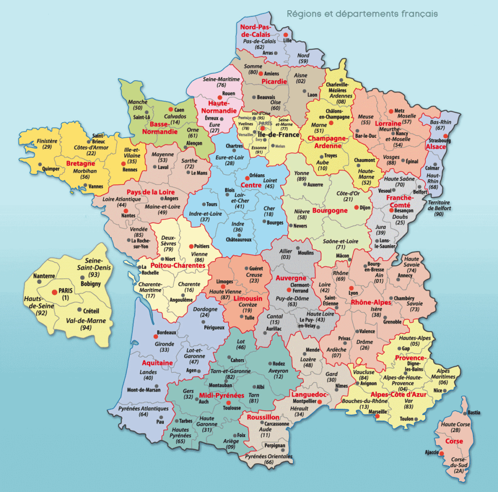
- With former regions (22 before 2016)
- In color or black and white
3. Maps with departments
The 101 French departments (96 metropolitan + 5 overseas) can be represented in different ways:
- With department numbers only
- With names and department numbers
- With prefectures indicated
- Blank base map with departmental boundaries
4. Thematic maps
Other specialized maps are available:
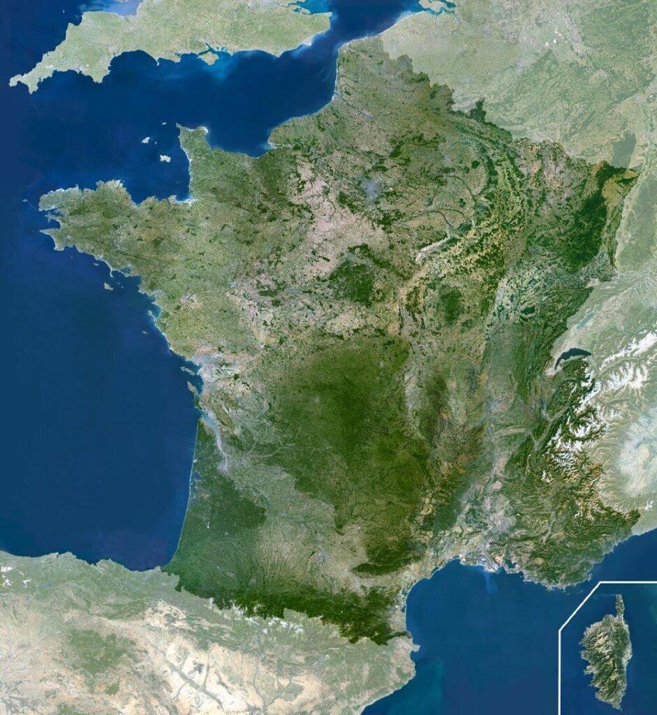
- Physical maps: relief, mountain ranges, rivers
- Maps with cities: main French urban areas
- Climate maps: climate zones of France
- Demographic maps: population density
Official sources to download free maps
Several official organizations and specialized sites offer downloadable maps of France for free:
1. Cartes-2-France.com
Dedicated platform offering:
- Wide selection of base maps
- Maps with complete municipal grid
- Maps with boundaries (municipalities, departments, regions)
- Maps with rivers, streams, and relief
- Free download without registration
2. IGN (National Institute of Geographic Information)
The IGN is the official reference source for French cartography. Its site offers:
- Base maps in multiple formats (PDF, JPG, SVG, AI, EPS)
- Maps of France with or without place names
- Maps with regional boundaries
- Various scales (notably 1:5,400,000)
- Color and black-and-white versions
IGN maps are free to use for educational and teaching purposes. They can be downloaded directly from the “Educational Resources” section of the IGN.fr website.
3. Éduscol (Ministry of National Education)
Éduscol provides teachers and students with:
- Base maps specially designed for teaching
- Maps adapted to school curricula
- Resources for sketching and cartography
- Thematic maps (relief, urban areas, climates, population)
4. Webvilles.net
This specialized site offers a comprehensive collection of maps:
- Maps of the 13 new regions
- Maps of the 101 departments with names and numbers
- Blank map backgrounds to fill in
- A4 formats ready to print (PDF and JPG)
- Free and open-use maps
Blank maps of France: complete guide
Blank maps are the quintessential educational tool for learning French geography.
Advantages of blank maps
| Advantage | Description |
|---|---|
| Educational flexibility | Allows adapting the exercise to the students’ level |
| Active learning | The student actively participates by filling in the map |
| Reusable | Can be used for several different exercises |
| Easy assessment | Ideal for quizzes and knowledge tests |
| Educational coloring | Allows visual differentiation of regions |

A map of France without labeled information. The 13 regions after the 2016 reform are outlined (red color) and colored to be better distinguished. The departmental boundaries are in gray. The map of France only concerns the metropolitan territories.
Available versions
Blank maps come in several versions:
- Simple blank map: only the outline of France
- With regional boundaries: 13 metropolitan regions outlined
- With departmental boundaries: 96 metropolitan departments
- With overseas departments (DOM): including the 5 overseas departments
- With neighboring countries: showing borders with neighboring countries
Maps with the 18 French regions
Since the territorial reform of January 1, 2016, France has 18 regions in total.
The 13 metropolitan regions
Here is the complete list of metropolitan France regions after the reform:
- Auvergne-Rhône-Alpes
- Bourgogne-Franche-Comté
- Brittany
- Centre-Val de Loire
- Corsica
- Grand Est
- Hauts-de-France
- Île-de-France
- Normandy
- Nouvelle-Aquitaine
- Occitanie
- Pays de la Loire
- Provence-Alpes-Côte d’Azur
The 5 overseas regions
The overseas regions (which are also single-department departments):
- Guadeloupe (971)
- Martinique (972)
- French Guiana (973)
- Réunion (974)
- Mayotte (976)
Maps of the former regions (before 2016)
Some sites still offer maps with the 22 former regions for educational or historical reasons. These maps are useful for:
- Understanding territorial evolution
- Studying documents prior to 2016
- Comparing the old and new divisions

Another map of France showing the 22 regions (before the 2016 regional reform). This map only includes metropolitan regions. Since the regional reform, the number of regions has decreased from 22 to 13.
Maps with the 101 French departments
The French departments constitute the second level of local government after the regions.
Distribution of departments
| Zone | Number | Numbering |
|---|---|---|
| Metropolitan | 96 | 01 to 95 (except 20) + 2A and 2B (Corsica) |
| Overseas | 5 | 971, 972, 973, 974, 976 |
| Total | 101 | – |
Types of available departmental maps
The maps with departments come in several formats:
- With names and numbers: complete map for consultation
- With numbers only: to test knowledge
- With prefectures: indicating the capital of each department
- Blank with outlines: for filling exercises
Available formats: PDF vs JPG
Maps of France are generally offered in several file formats:
PDF Format
Advantages:
- Quality preserved regardless of zoom
- Optimized for printing
- Maintains exact dimensions (A4, A3 format…)
- Reduced file size
- Compatible with all operating systems
Ideal for: Direct printing, digital distribution, archiving
JPG/JPEG Format
Advantages:
- Direct viewing in the browser
- Editable in all image software
- Easy insertion into Word, PowerPoint documents
- Compact file size
Ideal for: Integration into presentations, graphic editing
Other professional formats
The IGN also offers vector formats for professional use:
- SVG: web vector format, resizable without loss
- AI: Adobe Illustrator, for advanced graphic editing
- EPS: universal vector format for printers
Educational use of printable maps
For teachers
Printable maps are an essential educational tool for geography, history, and civic education classes:
- Lecture: visual support to explain territorial organization
- Practical exercises: locating regions, departments, cities
- Assessments: knowledge tests with blank maps
- Group projects: creation of personalized thematic maps
For students
Maps help students to:
- Memorize: spatial visualization of regions and departments
- Review: support for studying before tests
- Create: personal cartography projects
- Understand: administrative organization of the territory
Effective Learning Method
Here is a progressive method to learn the geography of France:
- Step 1: Identify the 4 cardinal points and the general shape
- Step 2: Locate the 6 main mountain ranges
- Step 3: Draw the 5 main rivers
- Step 4: Place the 4 seas and oceans bordering France
- Step 5: Memorize the 13 metropolitan regions
- Step 6: Learn the departments region by region
- Step 7: Locate the main French cities
Fun Activities
Make learning more fun with these activities:
- Color-coded coloring: each region a different color
- Speed game: who fills the map the fastest?
- Giant puzzle: cut out and reassemble the map
- Personalized map: draw your own travel itinerary
Tips for Quality Printing
Recommended Printing Settings
To get the best result when printing:
- Paper size: standard A4 (21 x 29.7 cm), or A3 for wall display
- Orientation: Portrait for the whole of France, landscape for certain regions
- Quality: High quality or minimum 600 dpi
- Color: Color for thematic maps, black and white for exercises
- Paper: 80g/m² for everyday use, 120-160g/m² for display
Black and White Printing
To reduce printing costs:
- Choose the black and white versions offered by the sites
- Set the printer to “grayscale”
- Use “draft” mode for practice exercises
- Reserve high quality for final documents
Lamination and Preservation
For durable use:
- Hot lamination: optimal protection for wall posters
- Cold lamination: economical solution for frequently used documents
- Transparent sleeves: simple and reusable protection
- Rigid cardboard: mounting on support for easy handling
Conclusion
Printable maps of France are an essential educational tool for learning French geography. Thanks to the free resources offered by IGN, Éduscol, Régions-et-Départements.fr, and CartesFrance.fr, you have access to a wide selection of professional-quality maps, downloadable in PDF and JPG formats.
Whether you are looking for a blank map for exercises, a map with regions to review the new territorial organization, or a map with departments to memorize the 101 French departments, you will easily find the resource suited to your needs.
Do not hesitate to visit the official websites mentioned in this article to download your maps for free and enjoy formats adapted to all uses: teaching, revision, professional projects, or personal use.
💡 Final tip: Print several blank copies and keep them in a plastic sleeve. This way, you will always have a map available for your geography exercises without having to reprint each time.
Frequently Asked Questions
Where to find a blank printable map of France for free?
Several sites offer free blank maps of France: IGN (National Geographic Institute), Éduscol, Régions-et-Départements.fr, and CartesFrance.fr. These maps are downloadable in high-quality PDF and JPG, ready to print on A4 format.
Which format to choose to print a map of France?
The PDF format is ideal for printing because it preserves the original quality. For a standard map, choose A4 format (21×29.7 cm). For wall posters, opt for A3 format or larger. High-resolution JPG files (>1000px) are also suitable.
What is the difference between a blank map and a map base?
A blank map shows only the outlines of France without place names. A map base may include additional elements such as the boundaries of regions or departments, but without their names. Both are designed to be filled in by the user.
How to use a printable map of France for school?
Printable maps are ideal for learning geography: locating regions and departments, placing main cities, tracing rivers, identifying mountain ranges. Students can color, annotate, and complete blank maps to memorize French geography.
How many regions and departments does France have in 2025?
France has a total of 18 regions: 13 regions in metropolitan France and 5 overseas regions (Guadeloupe, Martinique, Guyana, Réunion, Mayotte). It also has 101 departments: 96 in metropolitan France and 5 overseas.
Sources and References
- IGN – National Institute of Geographic and Forest Information
- Éduscol – Educational resources for teaching
- Cartes-2-France.com – Map bases of France
- Ministry of National Education – School curricula
- INSEE – National Institute of Statistics
- Vie-Publique.fr – Territorial organization of France
- Canva – Blank map templates